Geologia della zona del Sass de Putia (Peitlerkofel) - Dolomiti
Il massiccio del Sass de Putia fa parte del Patrimonia Naturale UNESCO è mostra tutte le formazioni rocciose tipiche delle Dolomiti. La gola del Moibach fornisce una bella visione sugli strati del periodo pre-dolomitico. La loro formazione geologica con le sequenze di strati sotto le montagne aumentanti della montagna del Putia, trovantesi sopra esso, è come un libro aperto di storia di terra. Da questo può leggere la genesi dei dolomites prima di molti milioni anni nel Marea Tetis e le influenze successive dei ghiacciai e del tempo.
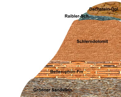
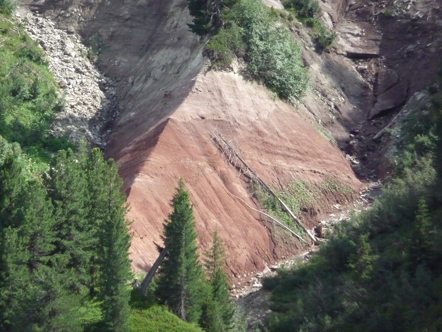
Il Sass de Putia è appena NE del grande Distretto Bolzano vulcano, limitato da una perturbazione, che ha conosciuto un massiccio vulcanismo in anticipo Permiano. L'erosione dei prospetti del vulcanismo ha portato alla deposizione del cosiddetto arenaria Val Gardena, che è abbastanza aperta a sud del giogo di condimento e si trova direttamente sulla varisica sotterraneo. La formazione di Bellerophon situata sopra l'arenaria di Val Gardena.
Lo spessore totale di arenaria Gardena è di circa 225m, che la formazione a Bellerophon sovrastante più di 100m. Quest'ultimo è interrotto da un circa 40m di spessore, una lingua da arenaria di Val Gardena a mettere su un altro 80.Le sequenze nell'arenaria Gardena sono formate da serie, il da grossolana a muoversi bene. Nel riquadro superiore degli strati Bellerophon si verificano quindi isolati orizzonti di dolomia non rappresentata nelle lagune. L'arenaria di Gardena è ricoperta da della formazione a Bellerophon. Un aumento di livelli del mare è alla deriva, poiché qui ha depositi di calcari grigi scuri e Marne, che ha salvato un intero altra fauna di molluschi fossili da strati superiori della formazione.
Sommario può essere che le rocce vulcaniche, logorate dall’erosione di fiumi della zona scaffale di Tethys sono stati trasportati il distretto del vulcano di Bolzano e ci hanno fatto enorme conoide alluvionale trovato così.Più fluttuazioni del livello del mare hanno portato a sequenze diverse di deposito. Gradualmente in corso tettonico abbassamento della zona scaffale di Tethys la sedimentazione - hanno cambiato quindi le condizioni di depositi di calcare e Marna calcarea con la formazione di barriere coralline e lagune. Che testimoniano gli strati di Bellerophon.
Per loggare questa cache inviatemi le risposte ai seguenti quesiti e postate una foto di voi (o del vostro GPS)
1) Quali differenze vede la formazione della Val Gardena in confronto della formazione a Bellerophon?
2) Scegliere l'orientamento di questo affioramento con la bussola.
In seguito potete immediatamente loggare. Se qualche cosa non è corretto, vi contattiamo.

Geologie im Bereich des Peitlerkofels (Sass de Putia) – Dolomiten
Das Peitlerkofel-Massiv gehört zum UNESCO Weltnaturerbe und weist Vorkommnisse aller typischen Gesteinsschichten der Dolomiten auf. Die Moibach-Schlucht gibt Einblick in die Geologie der Vor-Dolomiten-Zeit. Ihre geologische Formation mit den darüber liegenden Schichtfolgen unter dem aufragenden Riffgebirge des Peitlers ist wie ein aufgeschlagenes Buch der Erdgeschichte. Daraus kann man die Entstehung der Dolomiten vor vielen Millionen Jahren im Urmeer Tethys und die späteren Einflüsse der Gletscher und der Witterung ablesen.
Der Peitlerkofel liegt gleich NE des durch eine Störung begrenzten großen Bozener Vulkandistriktes, der im frühen Perm einen gewaltigen Vulkanismus erfahren hat. Die Erosion der vom Vulkanismus gebildeten Erhebungen hat zur Ablagerung des so genannten Grödner Sandsteins geführt, der südlich des Würzjochs schön aufgeschlossen ist und hier direkt auf dem variszischen Untergrund aufliegt. Über dem Grödner Sandstein liegt die Bellerophon-Formation.
Die Mächtigkeit des Grödner Sandsteins beträgt ca. 225m, die der überlagernden Bellerophon-Formation weitere 100m. Letztere wird dann durch eine ca. 40m mächtige, eingeschobene Zunge aus Grödner Sandstein unterbrochen um sich noch weitere 80 m fort zu setzen. Die Sequenzen im Grödner Sandstein werden durch Serien gebildet, die von grob zu fein wechseln. Im obersten Bereich der Bellerophon-Schichten treten dann vereinzelte Horizonte von in Lagunen entstandenem Dolomit auf. Der Grödner Sandstein wird von der Bellerophon-Formation überlagert. Aus den oberen Schichten der Formation ist ein Ansteigen des Meeresspiegels abzuleiten, da es hier zu Ablagerungen von dunkelgrauen Kalken und Mergeln gekommen ist, die auch eine ganz andere fossile Mollusken-Fauna gespeichert haben.
Zusammenfassend kann also festgestellt werden, dass die durch Erosion abgetragenen Vulkangesteine aus dem Bozener Vulkandistrikt durch Flüsse in den Schelfbereich der Tethys transportiert worden sind und dort riesige Schwemmfächer gebildet haben. Mehrfache Meeres-Spiegel-Schwankungen haben zu unterschiedlichen Ablagerungssequenzen geführt. Durch eine sukzessive andauernde tektonische Absenkung des Schelfbereiches der Tethys haben sich dann die Sedimentations - Verhältnisse hin zu Ablagerungen von Kalken und Kalkmergeln mit der Bildung von Riffen und Lagunen verändert. Davon zeugen die Bellerophon-Schichten.
Bitte macht optional ein Foto von euch ODER eurem GPS (mit sichtbaren Koordinaten) und fügt es eurem Log-Eintrag hinzu.
Außerdem schickt mir eine Mail mit folgenden Angaben:
1) Welche Unterschiede erkennst du in der Grödner Formation im Vergleich zur Bellerophon-Formation?
2) Bestimme mit dem Kompass die Ausrichtung dieses Aufschlusses.
Danach könnt Ihr sofort loggen. Wenn irgendetwas nicht in Ordnung sein sollte, melden wir uns.

Geology in the area of Peitlerkofel ( Sass de Putia ) – Dolomites
The Peitlerkofel massif is part of UNESCO world nature inheritance and shows of all typical rock layers of the Dolomites. The Moibach ravine provides an insight into geology of the pre-time from the Dolomites. Their geological formation with the overlying layer sequences under the towering reef-mountains of the Peitler is like an opened book of the geological history. From this one can read off the genesis of the Dolomites millions of years ago in the Tethys ocean and the later influence of glacier and weather.
The Peitlerkofel ( Sass de Putia ) lies just NO of the big Bozener volcano district limited by a disturbance which has learned an enormous volcanism in the early Perm. The erosion of the elevations formed by the volcanism has led to the deposit of the so-called Grödner sandstone which is unlocked beautifully southern of the Würzjoch and lies here directly on the variszischen underground. ( Variszisch means the time of the mountain building from the Devon to the Perm) The Bellerophon formation lies over the Grödner sandstone.
The thickness of the Grödner sandstone is approx.. 225m, the overlaying Bellerophon formation another 100m. The latter is then interrupted by an approx. 40m powerful, slid tongue of Grödner sandstone to set himself even another 80m away. The sequences in the Grödner sandstone are build by series which changed from roughly too fine. Occasional horizons of dolomite arisen into lagoons then appear in the topmost area of the Bellerophon layers. The Grödner sandstone is overlaid by the Bellerophon formation. From the upper layers of the formation one can derive a rising of the sea-level because it has come here to deposits of dark gray lime and marl, which also have stored a completely different fossil mollusc fauna.
In summary it can be stated that the removed by erosion volcanic rocks have been transported by rivers out of the Bolzano volcanic district and flows in the shelf area of the Tethys ocean. There are formed gigantic alluvial sequences. Multiple sea-level fluctuations have led to different depositional sequences. The sedimentation-relationships have changed by a gradually continual tectonic lowering of the shelf area of the Tethys ocean. Limestones and calcareous clay have been deposited and it started with the formation of reefs and lagoons. The Bellerophon layers show this.
Make a picture of you or your GPS standing at this point. Please upload this picture optional with your log.
To successfully log this cache, please answer the following questions and mail the answers to us:
1) Which differences do you recognize in the Grödner formation in comparison with the Bellerophon formation?
2) Determine the orientation of this geological formation with the compass display.
After that you can give your log directly. If anything is not ok, we will contact you.
Quellen:
· http://www.adele-sansone.com/geoberg/Geologie/Suedtirol/peitlerkofel.htm
· Società geologica italiana
· Wikipedia
· Foto eigen